Pope Soil & Water

Providing Quality Conservation Resources since 1949

Providing Quality Conservation Resources Since 1949
  • Home
  • Products & Services
  • Programs
    • Agricultural Conservation Programs
    • Urban Conservation Programs
    • Lakes, Streams, Researching & Monitoring
      • Bonanza Valley Ground Water Management Area
      • Lake Reports
      • Rosholt Research Farm
  • Projects
  • Education
    • Annual Poster Contest
    • Conservation Education Day
    • Envirothon
    • Legislative Days
    • Outstanding Conservationist
    • Pope & Stevens County Waterfest
    • Stewardship Week
  • About Us
    • Board of Supervisors
    • Conservation Partners
    • Conservation Plans, Data, and Reports
    • Employment
    • Meeting Minutes
    • Newsletters
    • Request for Proposals
    • Staff Page
  • Grant Reporting
  • Contact Us

Walk In Access Program

WalkInAccessThe primary objective of the Walk In Access Program is to provide new hunting opportunities on private lands currently enrolled in conservation programs with quality wildlife habitat, such as the Conservation Reserve Enhancement Program (CREP), Conservation Reserve Program (CRP), Reinvest in Minnesota (RIM), and the Wetlands Reserve Program (WRP). Other natural lands may also be eligible for enrollment if high-quality habitat exists.

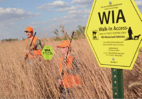
In 2014, Minnesota had 20,708 acres enrolled into the Walk In Access Program and Pope County had 10 sites totaling 555 acres. Once enrolled, the land is open to public hunting access during any open hunting season, including spring turkey. The location of areas enrolled will be publicized in an annual book and posted on the DNR website. Bright yellow-green signs will be installed along WIA boundaries once land is enrolled. WIA land is for hunting only. There is no target practice, trapping, dog training, camping, horseback riding, driving, or fires allowed on the property. Landowners are protected from liability, unlike private leases. Trespassing and hunting violations will be dealt with by DNR Conservation Officers.

Eligible sites must meet the minimum size of 40 acres. Acreage smaller than 40 acres may enroll if the land is contiguous with a Wildlife Management Areas (WMA), Waterfowl Production Areas (WPA), or another WIA resulting in at least 40 contiguous acres open to public hunting. Landowners sign into a one year or multi-year contract, with the ability to cancel the contract at any time without penalty.

Payment rates for signing up with the WIA program include:
· $10/acre base payment
· $1/ac. incentive payment if area is more than 140 acres
· $1/ac. incentive payment if land is located within a half-mile of other public hunting (WMA/WPA)
$1/ac. incentive payment for a multi-year agreement.

So if you have land in CRP, RIM, WRP, CREP, or any other conservation program and would be interested in earning extra money off of it please contact the Pope Soil & Water Conservation District. You can stop by our office at 1680 Franklin St N in Glenwood or call us at 320-634-5327. We would be happy to answer any questions and assist with enrollment of your land. For more information, you can also visit www.mndnr.gov/walkin. Deadline for enrollment is June 1st, 2015.

Well Sealing Program

Pope SWCD has some funding to provide cost-share assistance for well sealing.  The SWCD will contract with the property owners to share the cost of priority-abandoned wells.  In turn, the property owner must contract with a state-licensed well sealing contractor to perform all necessary work.  All work must be done in accordance with the Minnesota Well Code, including the filing of a sealed well record with the Minnesota Department of Health.  Upon completion of all of the required work and the submission of the required documents to the SWCD, reimbursement to the property owner will be made.

The Pope Soil and Water Conservation District (SWCD) has funding available to seal abandoned wells in the County. This funding is available as cost share assistance because of the County Water Plan on a first come first serve basis. Limited funding is available on a voluntary basis. Owners of the privately owned abandoned wells in the County will be entitled to apply for cost share at a rate of 75% of the total cost per well, not to exceed $500.00 per well.

The completed applications will be reviewed and approved by the Pope SWCD board of supervisors. Applications procedures are as follows:

  1. Complete the attached well sealing application form as accurately as possible and return it to the address listed at the top of this form. A cost estimate is required from a licensed well driller as part of the application.
  2. Wells will be given top priority ranking and selected for cost sharing according to the information received in the application.
  3. Wells approved for cost share will be required to sign a cost share contract.
  4. Upon notification of approval, your licensed contractor can proceed with the well sealing. The work must be completed by the date shown on the cost-share contract or the cost-share will be forfeited.
  5. The owner is responsible for paying the well contractor for the entire well sealing costs.
  6. When the well sealing is completed, and after receiving a copy of the abandoned well record and a copy of the itemized bill, the SWCD will reimburse the well owner the specified amount in the cost share contract upon board approval at the next regular scheduled meeting.
  7. Applicants who seal wells prior to receiving a signed contract from the SWCD office will lose their eligibility for cost share.

Buffer Initiative Program

Resolution 01-15 Adoption of Buffer Initiative

Resolution 02-17 Adopt Summary of Watercourses for inclusion in Local Water Management Plan

Download Conservation Buffer Brochure
Learn more about Implementing Minnesota's Buffer Initiative-Department of Natural Resources Website

Conservation Buffers Information on Board of Water and Soil Resources Website


BUFFER UPDATES

The Buffer Law was signed by Governor Mark Dayton in 2015 requiring perennial vegetation buffers to be installed along lakes, rivers, streams, and public drainage ditches.  These buffers are designed to help filter out phosphorus, nitrogen, and sediment as well as provide wildlife habitat.

SWCD’s across the state of Minnesota have been working with landowners on installation of these buffers or review of the parcels for implementing alternative practices.  In Pope County approximately 4,445 parcels were reviewed initially with aerial imagery.  If a violation of buffer law is found; the Pope SWCD will be informing the enforcing agency and the Board of Water and Soil Resources.  Any appeals will be handled by the regulatory entity with the Pope SWCD staff providing technical information regarding the buffer law and the project site.  It will depend on where the public water or drainage ditch is located on who the enforcing entity is.  In Pope County it is either Pope County Land and Resource Management Office, North Fork Crow River Watershed District, or the Sauk River Watershed District.

Reminder to farmers/landowners that with spring tillage ahead, to communicate if you have a buffer on your field and not to till it up. If you have questions regarding your buffer, please contact Nicole Brede in our office at 320-634-5327.


BENEFITS OF BUFFERS

Conservation buffers are strips of perennial vegetation around rivers, streams, lakes, and wetlands that slow water runoff thus reduces soil erosion, sequesters excess nutrients, stabilizes riparian areas, and enhances water quality. Buffers include contour buffer strips, field borders, grassed filter strips, grassed waterways, living snow fences, riparian buffers, shelterbelts/windbreaks, and wetlands.
Benefits of conservation buffers include:

  • Slow water runoff
  • Remove up to 50% or more nutrients and pesticides in runoff
  • Remove up to 60% or more pathogens in runoff
  • Remove up to 75% or more of sediment in runoff
  • Reduce noise and odor
  • Serve as a source of food, nesting cover, and shelter for wildlife
  • Stabilize streambanks and reduce water temperature in stream
  • Reduce downstream flooding
  • Reduced risk of tractor rollover due to set back of steep ditch or creek

If you are interested in buffering any waterways on your property, you can stop into our office for more information on programs and available financial assistance.


MONITORING PLAN

§103F.48 RIPARIAN PROTECTION AND WATER QUALITY PRACTICES

  1. COMPLIANCE TRACKING OF ALL PARCELS SUBJECT TO THE BUFFER LAW
    • All parcels in the county are to be reviewed within a 3‐year timeframe. The SWCD will review all parcels once every 3 years. This will coincide with the new aerial imagery received by the Farm Service Agency. Google Earth may also be utilized or the Counties Pictometry Imagery.
  2. RANDOM SPOT CHECKS
    • Random spot checks will be done in addition to the tracking of all parcels within a 3‐year span. These checks may be conducted via aerial photo review or on‐site review depending on availability of updated aerial photos and the practice that is being checked/access to farms. A combination of both aerial and on‐site review may also be used.
    • The SWCD will conduct 25‐50 parcels on a random spot check each year outside of the scheduled area.
    • Note: ** There are approximately 4,445 applicable parcels in Pope County.
      • Additionally, the SWCD should review parcels of emphasis more frequently.
      • Previously non‐compliant
      • No‐till/Conservation tillage or cover crop alternative practice plans
      • Variable width buffers (i.e. Land O’ Lakes buffer tool, Decision Support Tool)
      • Other Alternative Practice Plans
      • Cost‐share funded projects (years 1,5,9 of contract)
      • Parcels of further emphasis (potential violators)
  3. PROCESS TO HANDLE COMPLAINTS
    • Pope SWCD will investigate public complaints related to buffer law compliance but documenting the compliant including, location, landowner, potential violation, etc. Pope SWCD will then further investigate the compliant by aerial review, landowner calls, and field site checks.
    • If a violation of buffer law non‐compliance is found Pope SWCD will inform the enforcing agency (Pope Land and Resource Management, North Fork Crow River Watershed District or Sauk River Watershed District) and the Board of Water and Soil Resources. A non‐compliance form will be filled out along with a map of the parcel and will be provided to the enforcing entity for follow up with the landowner.
    • Appeals will be handled by the regulatory entity with Pope SWCD staff providing technical information regarding the buffer law and the project site as requested.

For more information contact Pope SWCD at 320-634-5327.

Reinvest in Minnesota (RIM)

Reinvest in Minnesota (RIM) was established in 1986 is administered by the Minnesota Board of Water and Soil Resources. The goal of this program is to restore marginal agricultural land and protect environmentally sensitive areas by reducing soil erosion, enhancing water quality, minimizing damage to flood-prone areas, sequestering carbon, and supporting wildlife habitats. RIM easements are perpetual contracts that remain with the title of the land and all future owners are bound to its terms. The Landowner retains title to property and all associated rights and obligations of ownership aside from those that are restricted and transferred to the State in the easement. RIM enrollment is a competitive process and is announced periodically for specific practices:

  • Riparian Wetlands
  • Riparian Buffer Strips
  • Grasslands Reserve
  • Groundwater Protection
  • RIM-WRP Partnership
  • Flood Response

Reinvest in Minnesota FACT SHEET


  • « Previous Page
  • 1
  • 2
  • 3
  • 4
  • 5
  • Next Page »
320-634-5327
Pope Soil and Water Conservation District 1680 Franklin Street North Glenwood, MN 56334

Quick Links

PROTOCOL FOR PUBLIC PARTICIPATION AT SWCD MEETINGS adopted 10-17-23

_____________________

2026 Tree Order Form-Revised 4-10-26

2025 Fall Newsletter

2024 Annual Report

Rosholt Weather Station

2015 Buffer Initiative PDF

Local Recycling Programs

Pope County SSTS Loan
and Grant Program Information

Data Practices Policy

Public Data Request Form

About Rosholt Weather Service

Events, Etc.

Pope SWCD Board Meetings
Location: USDA Service Center, 7:00 am April through October, 8:00 a.m. January through March and November and December
December 16, 2025
January 20, 2026
February 17, 2026
March 17, 2026
April 21, 2026
May 19, 2026
June 23, 2026
July 21, 2026
August 18, 2026
September 15, 2026
October 20, 2026
November 17, 2026
December 15, 2026
January 19, 2027

All contents are the property of Pope County SWCD and are the views and opinions of the District. The District's goal is to provide quality and accurate information and products. All information within this site is subject to change and should serve only as a guideline for the districts services and procedures.

For the most accurate information, please call (320) 634-5327. Pope Soil & Water Conservation District prohibits discrimination in all their programs and activities on the basis of race, color, national origin, sex, religion, age, disability, political beliefs, sexual orientation, and marital or family status.

  • Home
  • Products & Services
  • Programs
  • Projects
  • Education
  • About Us
  • Grant Reporting
  • Contact Us

Copyright © 2026 Pope Soil & Water · Site by Versatile Designs & CYBERsprout